
Celebrating Mothers: Health in the Hands of Women

To celebrate Mothers´ Day today, and every day, Future Generations Peru happily agreed to share with the Future Generations community some basic information on their project called “Health in the Hands of Women” (MAM Project).
The stated project goal was to contribute to improving the health of mothers, newborns, and infants, and to reduce chronic child malnutrition. We wanted to demonstrate to the Peruvian Ministry of Health that it could effectively and sustainably implement at scale a model of primary health care organization and management in rural areas that could successfully support at scale a community-oriented system of health promotion that would reach mothers in the home to improve their home health knowledge and behaviors and improve maternal and child health status.
 A major component of the MAM Project strategy was the Modular Program for Training Female Community Health Workers (CHW) in Maternal, Neonatal, and Child Health. This was a behavior change strategy that introduced innovations in the Peruvian health sector for CHW trainers (primary health care personnel), supervisors and supporters of CHW (Community Facilitators who were community members), older community women as CHW, with teaching and training materials (flipcharts and facilitator manuals), and a CHW learning/teaching method (“Sharing Histories”).

A key project activity was the implementation and testing of the innovative teaching method for CHWs, called “Sharing Histories,” that empowers mothers through the sharing their own memories of their childbirth and child rearing experiences, hearing other´s experiences, and learning best practices by analyzing what was done correctly or incorrectly in the past. Female CHW gained self-confidence to speak in front of others, took ownership of their own experiences, and became more effective in their home visits to other women teach them better health practices. The MAM project tested the effect of the “Sharing Histories” teaching method as an embedded operations research project using a cluster-randomized controlled trial.
 MAM worked to improve the quality of care in health facilities (HFs) by changing health staff attitudes about community health outreach and guided the development of management teams in each HF to work together on community health plans and actions. We worked with them to do an initial self-evaluation and self-planning exercises for both of those purposes.
 The final evaluation studies of the MAM Project in 2014 were compared to baseline studies conducted in 2010, major findings showed major improvements in knowledge and practices of mothers related to health and nutrition of mothers, newborns, and children.
-
Significant reduction in chronic malnutrition in children 0-23 months of age whose mothers received one or more visits from a CHW, among mothers who could read.
-
Significant increases in knowledge of pregnancy, post-partum and newborn danger signs by an average of 16 to 48 percentage points.
-
Significant increase in newborns that were wrapped and dried immediately at birth (76% to 98%)
-
Significant increases in good hygiene and sanitation practices, including hand washing, disposal of infant feces, water treatment at the point of use, and reducing in-door breeding in dirt-floor kitchens of small animals (such as guinea pigs which are served for special meals).
-
Significant increase in the percentage of HF managed by CLAS Associations (43% to 70%).
-
Development of a new cadre of human resources for community health called Community Facilitators. All 47 of them continue to be paid stipends directly by the municipalities in 2017 for their work to support and supervise female CHW.
-
Community Facilitators and female CHWs are recognized by health workers as being key components for the HF-community health strategy.
-
Community Facilitators and CHWs are recognized by community authorities and municipalities as playing a critical role in improving community health.
-
The Huánuco Regional Health Directorate officially established a permanent “Center for Development of Competencies in Health Promotion” in the Acomayo Health Center which serves to sustain the new approach to community health promotion by guaranteeing the on-going training of trainers so they can continue the training and support to Community Facilitators and female CHWs on a wider scale.
-
Municipalities are increasing support to HFs by continued financing to the Community Facilitator stipends, training costs for monthly workshops, and non-cash incentives for CHW and Community Facilitators. Municipalities expanded their investment in contracting extra health personnel, constructing and remodeling infrastructure for health posts, providing equipment, implementing services (laboratory, maternity waiting homes), and providing fuel for motorcycles or bus fare for health personnel supervision to communities.

*CLAS are Local Health Administration Community Associations – private non-profit community organizations that collaboratively administer primary health care facilities under contract with the government.
________________________________________________________________
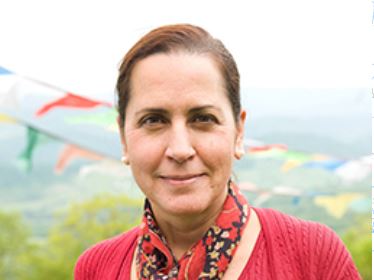
This week’s blog post and accompanying photos are kindly shared by Dr. Laura Altobelli, Future Generations University’s Professor of Equity & Empowerment (Health) and Director of Future Generations Peru. She has more than 30 years of experience in research, evaluation, and public policy innovation and advocacy, and uses these skills to bring scalable solutions for strengthening public health systems in developing countries.
Voices of Future Generations: Life in the Isle of Skye
By all counts, the Isle of Sky is an isolated and rugged place. In this episode of Voices, we hear about it from someone who grew up there.
“When people aren’t near services, you might tend to make more of an effort to do things together,” she suggests, while describing the community events and pastimes on the island.
The Treasured Natural Spring at Mount Moroto
Text and photos by Vincent Abura, MA student of class 2017
The Karamoja region of North-eastern Uganda has seen more than violent conflict for 40 years. As part of the Community Based Natural Resource Management Course in the Master of Arts degree program, Vincent looked at how stakeholders in a scarce and treasured water source are working together to protect the resource and share the benefits derived from it. The spring and its watershed are located in the red shaded area in Uganda below.

 |
| Photo caption: Two women are standing right in the protected spring and talking about how they manage it. |
Mr. Joseph Nyimalema, the Area Manager for National Water and Sewage Corporation (NWSC), informed me that NWSC operates under the Ministry of Water and Environment and is mandated to supply water to urban and rural communities. NWSC pumps 15,000 liters of water per hour to supply to the urban-rural populations. NWSC is a strong benefiting stakeholder of the watershed, without which it cannot meet its obligations. The interests of NWSC towards the watershed is legal ownership of land for its 2 water generators, security and safety of its equipment. NWSC recruited security guards to provide security for the assets and safety of water pumped for public consumption.
Arok Jimmy, the Chairperson of the 20-member Resilience Adaptation Committee (RAC), promotes greenhouse and sack gardening as well as soil and water conservation through terracing. They teach communities to grow vegetables and adapt to dry land cultivation. RAC’s interest in the spring is to access water for the greenhouses and sack gardens in homesteads, also in the availability of land in the watershed to control run-off water through terracing.
A local tree nursery is also interested in the spring. An attendant, Mr. Lokoru Bernard, informed me that they are planting different types of seedlings including: K-apples, Eucalyptus trees, papaws, mangoes, and indigenous species that are adaptable to drought in Karamoja. There are approximately one million seedlings planted this year. When converted to monetary terms (assuming a seedling is sold at UGXs 500) 1 million seedlings would amount to 500 million Uganda shillings, an equivalent of $143,000 US. The interests of the planters is to raise income for their households, which can only be done sustained spring water, employing as many boys and girls as possible and to seek popularity to attract financial support from various programmes.
 |
| Photo caption: The tree-nursery garden where the attendant is weeding the unwanted plants from the nursery. |
Over 2000 livestock drink from this spring on a daily basis. This is the most accessible and available safe water for livestock in the district. Other options include boreholes, which are shared with human populations and are overcrowded. To get the attention of the cattle keepers, I had to walk with them and their herds. According to one, Kotol Patrick, their interest is availability of water for livestock. He strongly asserted that, ‘without this source, there is no life for human beings who depend on animals for survival. We shall do everything possible, including fighting to death to ensure water is sustained for their main livelihood.’
In summary, many stakeholders depend on this spring and its watershed for their livelihoods and wellbeing. Many are actively involved in protecting the water, and each plays a unique and important role in the current use and future availability of this invaluable water source.
University Launches Multi-Country Peacebuilding Research Study
- Children are in school without disruption by rebels
- Being able to hold social events without police disruption
- How many dogs are barking at night
- Roads and other key infrastructure get repaired
- Women feel safe walking in the streets
- Able to access primary health care center
 |
| Photo caption: This map shows the 12 country sites (listed below) that are included in the current study. |
What does the Future Generations University adaptation of USIP’s work look like?
Musings of a Naturalist II: Gondwana Gardens
Text and photos by Dr. Bob Fleming
On our first day in northeastern Australia, in the Centennial Lakes Park in Cairns, we found an arrow pointing to the Gondwanan Evolution Garden.
A Gondwana Garden? I’d never heard of such a thing.
Gondwana, the southern part of the ancient supercontinent of Pangea, is a name well-known name in geological circles, but a garden? This was a first.
Then, on our last day in Australia, this time on Bruny Island off Tasmania’s east coast, we again came upon the concept of a Gondwana garden. Here on the 600 hectare (1,500 acre) Inala Private Reserve we explored their Jurassic Garden dotted with plants whose ancestors once grew on Gondwana.

As Australia is a continent isolated from others, it is quite understandable that many Australians are aware of the concept of plate tectonics and that continents move, ideas that were considered rubbish during my university days in the 1950s-1960s.
But how to explain the presence of kangaroos in Australia when they are not seen anywhere else in the world? The answer lies in the history of our planet.
Earth’s geological record shows that some 250 million years ago (mya) most of the world’s landmasses were melded into one supercontinent, now referred to as Pangea. Later, beginning around 185 mya, rifts appeared in Pangea and the huge landmass gradually split into two divisions, the southern section named Gondwana. In the ensuing millions of years Gondwana also fractured into parts and Australia is one of those remnants.
Today, much of the flora and fauna found south of the equator speaks of Gondwana. For example the Southern Beech, Nothofagus, survives today in an arc from southern Chile around to New Zealand, Tasmania and north into the mountains of New Guinea. Another example is the early cone-bearing Araucaria ‘pines,’ the distribution of which traces a similar arc from Chile around to New Guinea. Thus one now encounters the Monkey Puzzle tree in southern Chile (and as a garden ornamental commonly planted round the world), the Hoop Pine in Australia, and the Klinki Pine in New Guinea.
Both Nothofagus and Araucaria likely evolved in what was western Gondwana as an Araucaria fossil dating to 185 mya and Nothofagus fossil dating to about 135 mya have been found in beds from that region. Later, due to favorable conditions they continued to evolve and today survive on far-flung remnants of Gondwana.

Another Gondwana connection is seen in the Proteaceae family, illustrated by the colorful Banksias in Australia and the related Proteas from southern Africa. The parrot family is yet an additional link as members proliferate primarily in two areas of the world – Australia and South America. And then there are spiders. The closest relatives of the primitive Tasmanian Cave Spider (Hickmania troglodytes) are seen in Chile.
Species that evolved early may be driven extinct by climate change or out-competed by later arrivals but on isolated continents and islands with favorable conditions, protection may allow them to proliferate. As an example, 13 of the 19 recognized Araucaria species grow only on remote New Caledonia Island.
Kangaroos are the pride of Australia, the symbol of the Qantas, the national airline, and pictured on the Australian Coat of Arms. These pouched mammals (marsupials) speak not so much of a Gondwana connection but of continental isolation. Indeed, the flora and fauna we find today on whatever continent is the result of a combination of factors including genetic and geological history as well as both ancient and modern climates.
On our last morning in Australia, while admiring the plantings in the Inala Jurassic Garden, all arranged in family clusters, and thinking about the biological threads that connect these southern lands, we were watched all the while (albeit from a distance) by a Bennet’s Wallaby and a Forty-spotted Pardalote, representatives of families found only in Australia. The natural history of this continent is very special indeed.
